Travel Stories - Peru
"condors" in "colca canyon"

introduction
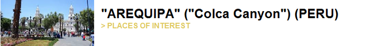
Yesterday we arrived after a long bumpy ride in the town of Arequipa. We met on the way another Dutch couple and have decided to check in at a hostel together. We had something else in mind after our “harsh” experience in Bolivia, but we have some days “left” and decide to join them in a tour tot he Colca Canyon. The owner of our family hostel knows someone who wants to take us on a three-day tour with us, namely himself. The next morning we wake up early and we crawl into the jeep for a new adventure.
"Reserva Nacional Salinas y Aguada Blanca"

We leave the city of Arequipa on the north side and drive further north to the National Park of "Salinas y Aguada Blanca". After we have passed the volcanoes "El Misti" and "Chachani" we arrive on a plateau - el altiplano - which is on an average of 4300 meters in height. The landscape is cork-dry, yellow-brown with some treeless hills here and there. If you would look at the pictures, you would say that it is a desert with the bright shining sun on it and the rocky surface. We drive through this desolate site and stop a little further. Our guide, driver, cook and hostowner points out to a number of vicas in the distance. The family of the domiciled lama is only slightly smaller and is seriously threatened. Dust and rocks splashes away when we drive off again and I don’t want to think of the idea of the car is out of petrol here. Before heading to the "Colca" Canyon we stop for a moment to see the "hard moss" that grows here. Local residents have made piles of stones for good luck. We have to wait a while when a herdman comes across a narrow path with her goats. The pass we need to get into the valley is 4800 meters high and from here the "Nevado Ampato" is also visible with its more than 6300 meters high and snowy peaks.

Yanque
The Colca Valley is about 100 km long and is as deep as the "Grand Canyon" in the United States. By contrast, the valley is still called "young"; the "Colca" River, which has made its way through the volcanic rock, has developed for less than 100 million years. The name Colca originated through the gaps that can be seen in the gorge. these holes are called Colca's. They were used by the Incas and Pre-Incas to store food for bad times, such as potatoes and other foods that could last longer. They were also used as graves for important people.

Our guide stops a bit further with the car so that we can walk a fair amount ourselves and get a real feel of the valley. Because it’s not as high than the plateau we just came from we can see beautiful cactus trees growing between the rocks and stones. Of course we hope to spot a "fishcacha" among the many rocks that lie here. It is a crossing between a marmot, squirrel and rabbit but unfortunately we don’t see one. It is wise to put sunscream on you’re face and hands because it’s very dry here, high and the sun is beating down on us, although you don’t feel it. Also the wind is blowing steady here which brings a fresh breece. It's late afternoon when we arrive in the vllage of "Yanque" where we apparently stay today. We pick up our bags from the roof of the jeep and put them in the house, which later turns out to be the owner's aunt's house. Our guide makes it clear that we have some time for dinner and it is nice to make a trip around this hamlet. The Dutch couple goes one way and we take the other. For me the setting is here is like an American western with those rapoles that blow through the empty abandoned streets. We take a look at the 18th century church that is located in the square and then we decide to go back to the house for diner. Food is served on a small wooden old table and tastes traditional and is superb. Not late we decide to go to bed. Hours later we get up for day two.
Condor Spotting

We put our alarm clock early yesterday evening early for a early start on our second day in the Canyon. After breakfast we tie our bags back on the roof and our driver / guide starts the engine. It is not far to "Cruz del Condor" (or "Chaglla") where just one other jeep is parked. The gap or valley we see in front of us is the residential area of a family of "Andes condors". This very endangered bird flies in the morning (and in the evening) on the air of its place deep in the gap upward. In this way, at one point he comes so close that it looks like you can grab him from the air. During the day, he can fly 200 km to find dead carcasses he mainly lives on. It is 07:00 in the morning and we are looking forward to the 1200 meter deep valley. Not much later, when another jeep has arrived, we see a dot approaching us from down deep below us. One moment you see him, then he’s gone again. He’s zigzagging from one side of the valley tot he other and comes closer everytime we see him. It is a beautiful black and white bird that reaches a span of 3 meters! It is one of the largest birds in the world. If the bird still flies among us, we'll mark a second one. Very hard to get a good picture of them. Suddenly we are on the same level then this magnificent bird and it looks like you can stroke him – a minute later he’s high up in the air and goes for another day of hunting pray. What an experience!

The Condor (bird):
The Andescondor can be found throughout the Andean from Venezuela, via Colombia, Ecuador, Peru and Bolivia south to Argentina and Chile. Sometimes the specie comes as a kind of (temporary) guest in Brazil and Paraguay. In the north of the Andes, the Andescondor has become more rare.
The span of the Andescondor is about 3 meters and only the large albatross has a larger span. However, the condor has the largest wing-surface /area of all flying birds. The head-tail length is around 1.2 to 1.3 meters. The weight of the males can be 11 to 15 kilos while the females are slightly lighter. The Andescondor, like many other vultures, has a bare head that is easier to keep clean. The adult birds have black feathers and a white collar, which is larger by the males. An adult bird have have large white spots or tires on their wings. The males head is crowned by a large red comb, and the neck shows skin folds. The crown and neck skin may turn red, which is used to exchange social signals with peers. The females lack the comb. The condor can live at an altitude of 3,000 to 5,000 meters and floats on the thermal bubbles, for example, by leaving early in an morning from an Andean valley and thus moving up by using warm air. The Andescondor is being threatened at the moment and the numbers are slowly declining. This is caused by local farmers who see the condor as a threat to their livestock.
Cabanocade and Sangalle

It is a long drive away before we arrive in another traditional village of the Colca Canyon called "Cabanocade". Also here – very few people on the streets. We have lunch at a local restaurant. Our guide indicates the road where we will start our hike towards Sangalle which lies in the valley. He tells us that the route cannot be missed and we are heading into the heat of the day. The first piece is flat and the gravel path lies between tall bushes on both sides. In the distance we see the now-known agricultural terraces and some bare hills. The sweat guts out of my forehead and dust rises from the gravel. Suddenly we stand at the edge of the cliff and the guide points to the oasis we see at the river in the deep gorge. We see palm trees and a beautiful clear blue swimming pool. That’s the oasis where we sleep tonight. We just have to climb down there tot he valley. Big rocks, dust and many spiky and big cactus trees look at us while climbing down. The path is steep but after our hike in the Andes moountains (the Inca trail) nothing is hard for us anymore. Still, we spend about 2 hours in total walking down to our place for the night.
Below in the valley we are appointed our cabin and we prepare our beds. It is a hut f straw with four shelves that should serve as a sleeping place. The guide makes it clear that we can swim in the pool or take place under the trees on the terrace because we’ve got some time left for diner. After a fresh dip in the very cold pool we order a cold (but pricey) beer and then enjoy a delicious but simple dinner under the trees. After dinner the sun goes down and it cools off immediately. I’ts not late when we turn into our huts to get under the blankets.

Chivay and the geysers
After breakfast we pack up our items and prepare for a tough walk uphill. We know the route ofcourse but what that doesn’t matter. It’s still harder than we thought it would be. It's lunchtime when we get up and head back to the village of Cabanaconde. Our bones hurt and we sweat all over. We still have a point of interest and that is the town of Chivay and its hot springs. Chivay is the capital of the valley and lies at more than 3500 meters high. After we have seen the square and the market of this vibrant place we go to its peak. the "La Calera" geysers. The water surges and burl up and after a short walk around the geysers we decide to go back. We had a fantastic time but it’s enough. We want to go back to the hostel, clean up and have a nice hot shower. We are tired and decide to drive back to Arequipa.

see also:
LANDEN:
EUROPA:
Albanië * België * Bosnië-Herzegovina * Bulgarije * Denemarken * Duitsland * Engeland * Estland * Finland * Frankrijk * Griekenland * Hongarije * (Noord) Ierland * Italië * Kosovo * Kroatië * Letland * Litouwen * Luxemburg * Macedonië * Malta * Montenegro * NEDERLAND * Oekraïne * Oostenrijk * Polen * Portugal * Roemenië * Rusland * Schotland * Servië * Slovenië * Slowakije * Spanje * Tsjechië * Turkije * Zweden
NOORD EN CENTRAAL-AMERIKA:
Chili * Costa Rica * Cuba * Guatemala * Mexico * Nicaragua * Panama * Verenigde Staten
ZUID-AMERIKA:
Argentinië * Bolivia * Brazilië * Colombia * Ecuador * Peru
AFRIKA:
Botswana * Burkina Faso * Egypte * Ethiopië * Ghana * Kenia * Mali * Marokko * Namibië * Oeganda * Senegal * Tanzania * Tunesië * Zuid-Afrika
MIDDEN-OOSTEN:
Iran * Israël * Jordanië * V.A.E.
AZIE:
Armenië * Cambodja * China * Filipijnen * Georgië * India * Indonesië * Japan * Kirgizië * Laos * Maleisië * Mongolië * Myanmar * Nepal * Oezbekistan * Singapore * Sri Lanka * Thailand * Vietnam
OCEANIE:
Voor meer reisfoto's kijk op www.instagram.com/cheapskatetravel.nl:

© Cheapskatetravel.nl; 2018 (all rights reserved)