Travel Stories - France
"le linge"

introduction
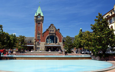
We arrived by bus in Mulhouse. From here we must apparently travel back to the French city of Colmar to go to our day destination for today "Le Linge". Sitting in the train we almost miss our stop because we thought the train trip would take one hour but it’s only 20 minutes. Because we are going to see so many more beautiful villages, we decide not to walk through Colmar (we miss the time too) and to travel directly to the city "Orbey" by bus. Because we’ve got some time on our hands we decide to sit in the sun next to the beautiful fountain in front of the trainstation. I catch my travelguide from my big back and start to read about Colmar. I would love to read a bit more about the importance of the city during WW2 but just the name “the pocket of Colmar” is mentioned without any explanation. There are also no museums in that genre or other remains from that time.
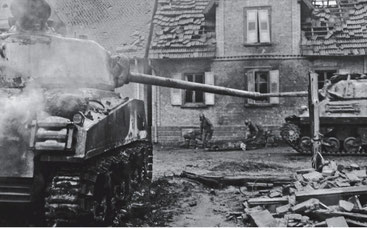
The Colmar pocket (WW2):
The Germans had been expelled from France in 1944 by the Allies in WW2 but in the Colmar area the Germans gathered at the end of that year to re-conquer the “Alsace” region again. They also engaged fresh troops to start the reconquest of Alsace from this area. The French and Americans had too few and too tired troops and they had to set up a line of defense instead of pushing on to Colmar. Meanwhile, the battle of the Ardennes (the Ardennes offensive of Battle of the Bulge) took place, which meant that the supplies first went there. On January 20, 1945, the Allied offensive started to eliminate the Colmar's pocket and thereby allow as few Germans as possible to escape. It was attacked from the north and the south to strike a wedge between the Germans and the Rhine on both sides, making withdrawal impossible. Due to the heavy resistance from the Germans and the snowstorms, the French did not reach the set goals the first day. The second day was a great success, but on the third day the Germans started a counterattack. After this the fights were very fierce and village after village had to be conquered. The Germans, however, had a shortage of material. Everything they had on artillery and infantry had been prepared. But they were not allowed to withdraw from Hitler. It was not until 27 January that German troops received permission to cross the Rhine and to give up all the territory in Alsace. On 9 February the Germans blew up the last bridge over the Rhine at Chalampé. 16,000 Germans were taken prisoner of war and 20,000 were killed, but 50,000 could have escaped. This is also sometimes called "Colmar Pocket" or the "bag of Colmar".
"Parc Naturel Régional des Ballons des Vosgues"
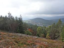
Looking out the window of the bus we see the "Parc Naturel Régional des Ballons des Vosges". We pass many "German villages" until I approach the driver to tell him or say that we want to "Le Linge". The man tries to explain that the bus doesn’t go that far but he will bring us tot he furthest point. From there we’re on our own. When he stops what looks like the end of the world I ask him if the girl from the trainstation was right when she said that “Le Linge” from here was about a 30 minutes walk. He takes us outside the town "Orbey" where he turns the bus and goes back. Assuming that the driver is right, we stretch our legs and start to walk - uphill! Less than 100 hundred meters further, we have to hide for a terrible hailstorm that suddenly comes down. After that we stick our thumbs up for a lift "afraid" of another storm. Not much later, a French teacher who speaks excellent English stops and she wants to drop us at the intersection. At that crossroads also appears to be a large German cemetery ("Weltstein") and we feel that we are close. Despite the feeling, it is still quite a walk through the forest before we see the hectometer pole mentioned in our travel guide. There we walk up the path and have a beautiful view of a valley.
Circuit "1914-1918"
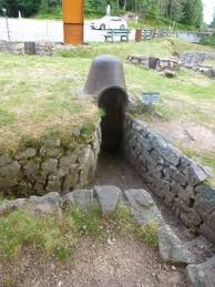
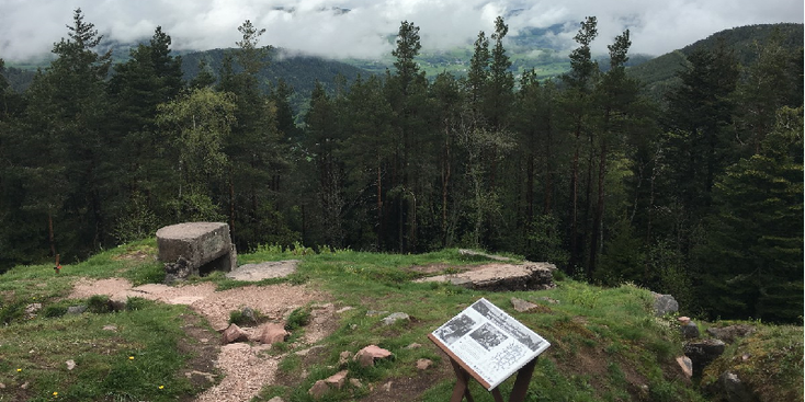
Where "Le Linge" is well known for are the trenches from WWI which are still in good a condition here. So we go looking for them and/or looking for a sign. We come across a few hiking signs with the inscription "circuit historique 1914-1918" but the trenches we see here are more like "dried up streams". We also find some concrete parts of what might have been a bunker, but there is no sign of a museum. The wounds that the Great War has struck in this mountain are for the most part covered by nature. It is hardly imaginable that this peaceful, sometimes idyllic region looked like a lunar landscape in 1915. Through the compass and climbing a high hill we decide to walk back to the road where we meet a group of children with a guide who are on their way to the museum. We decide to eat something on a few tree trunks, so that we can walk behind the children later and follow their path. We now also see the monument "Chasseurs d'Alpes" (mountain hunters). After climbing up the hill again uphill, we see the French flag and the museum.
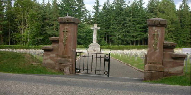
The museum is filled with display cases full of photos and remains such as weapons, personal items, ammunition and relics of the battle that took place here during WW1. You can also see videos and scale models. Strategically, it was a very important place for the Rhine Valley and Colmar where the Germans wanted to keep their positions at all costs. Especially the German helmets that were "soft", of fabric and the puppets with uniforms are impressive. When we come outside, I realize that the well-kept trenches are part of the museum and we can even walk through the trenches. They are narrow, deep and chopped from the sandstone of the mountain. Also the German headquarters, the "Blockhaus" is still visible. It still looks amazingly good that we get the feeling of walking through a film set of a war film. The French positions can be seen from here - so close but not accessible; probably because there are still mines or explosive ones close to the surface. There is also a large degree of barbed wire still present and the graves under which German and French soldiers are buried do gloomy.
The fighting on and around "Le Linge" (WWI):
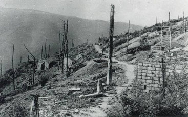
"Le Linge" is one of the three mountain peaks (the other are Barren and Schratzmann) where in the First World War the Germans and the French fought some severe battles because of its strategic location and its quarries. After the Franco-Prussian war in 1870, the Germans had taken over the provinces of Alsace and Lorraine from the French, which struck them deep in their national pride. The Germans had well excavated positions in the Vosges on what they called "the Lingekopf Festung" in the sandstone mountain peak that reached almost 1000 meters hight. The French launched their major attack on 20 July 1915 to reach the strategic city of Colmar. The trenches were at some points no more than 100 meters apart. During the second attack on July 26, the French succeed in occupying the crown and top of the Linge where the Germans bombed and shelled their former positions and French lines. Requests from the French for reinforcements were rejected by the headquarters. Between July 29 and August three fierce battles took place between the two sides, without any of the parties making any gains. On August 4, a German bombing with 40,000 grenades followed the French positions. The fighting continues as before. Finally, the French conquered the summit of the Schratzmännle on 22 August.
Three days later, the first wave of French attacks comes to an end. On August 31 the Germans started a counterattack. Gas grenades are used for the first time on this front. The ground attack that followed results in some gain, but not enough. A new gas attack followed on 9 September, followed by an attack with flame throwers. On October 12 and 15 the two final German attacks would follow, but it will not be possible to drive the French completely away from the Lingekopf. They continue to occupy the Western slope, a position that is strategically of little use. The Germans continue to keep the view of the Alsatian plain and Kaysersberg. Sometimes the battle results in a hand to hand fighting between several nearby trenches of the sworn enemies. In this period, more than 15,000 victims would fall and the area would have changed into a lunar landscape. The Germans would also try a counterattack several times with the use of gas grenades and flame throwers but without any result. The struggle would continue until the capitulation of Germany in November 1918.
Still reminiscent of the interesting scenery and the view we walk back across the road and we stop a passing car that brings us back to the intersection at the German cemetery. Not much later a passenger is ready to drive us to "Orbey" where we fill our gas bottle and take supplies. We really want to camp here - but the hills are so steep that we decide to get a new lift - we stop a car from a South African guy who likes to take us to "Kaiserberg". Just before the village we say goodbye to him and we walk on the right side an open piece of land on what looks like a parking place - we walk along the mountain and find after 5 minutes a good wild camping spot to spend the night. After an evening meal consisting of bread and sausage, we are ready for our first night in our tents, hoping for a good night's sleep.
tips & advice (2010)

-
Name: Musee Memorial "Le Linge" 1914-1918
Address: 86 rue du Général de Gaulle, Orbey
Price: € 3.50
Phone nr. : 03 89 77 29 97
Website: http://www.linge1915.com
Content:
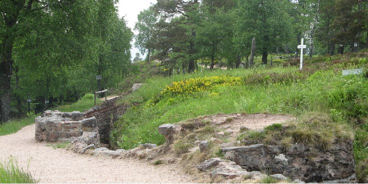
The museum is located about halfway the summit on the mountain "Le Linge" at the edge of one of the hairpin bends leading to the peak. Despite the fact that it is not a large museum you get a good picture of the horrors that arose here during the war (WW1) that have played here between the Germans and French. Through weapons, photographs, letters and other weaponry you are sucked into the miserable state that must have prevailed here. You can read about the type of bed spirals that were used to throw away grenades and/or catch them. Outside you step into reality - small trenches (the best preserved worldwide) so close together that it is almost unthinkable. Where now trees grow was at that time a bare plain where you had an even better view over the whole valley. To this day large pieces have been deposited where mines, charred undergrowths, trenches, bunkers and ammunition are located. A gripping museum.
see also:


LANDEN:
EUROPA:
Albanië * België * Bosnië-Herzegovina * Bulgarije * Denemarken * Duitsland * Engeland * Estland * Finland * Frankrijk * Griekenland * Hongarije * (Noord) Ierland * Italië * Kosovo * Kroatië * Letland * Litouwen * Luxemburg * Macedonië * Malta * Montenegro * NEDERLAND * Oekraïne * Oostenrijk * Polen * Portugal * Roemenië * Rusland * Schotland * Servië * Slovenië * Slowakije * Spanje * Tsjechië * Turkije * Zweden
NOORD EN CENTRAAL-AMERIKA:
Chili * Costa Rica * Cuba * Guatemala * Mexico * Nicaragua * Panama * Verenigde Staten
ZUID-AMERIKA:
Argentinië * Bolivia * Brazilië * Colombia * Ecuador * Peru
AFRIKA:
Botswana * Burkina Faso * Egypte * Ethiopië * Ghana * Kenia * Mali * Marokko * Namibië * Oeganda * Senegal * Tanzania * Tunesië * Zuid-Afrika
MIDDEN-OOSTEN:
Iran * Israël * Jordanië * V.A.E.
AZIE:
Armenië * Cambodja * China * Filipijnen * Georgië * India * Indonesië * Japan * Kirgizië * Laos * Maleisië * Mongolië * Myanmar * Nepal * Oezbekistan * Singapore * Sri Lanka * Thailand * Vietnam
OCEANIE:
Voor meer reisfoto's kijk op www.instagram.com/cheapskatetravel.nl:

© Cheapskatetravel.nl; 2018 (all rights reserved)