Tours - Nepal
"annapurna" circuit (trekking)

introduction

- Permit required: Yes
- Entrance: 2000 Rs (national park) (2004)
- Number of km: about 340
- Number of days: about 13
- Number of hours: about 80
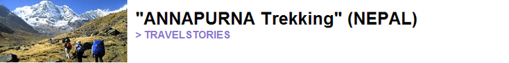
The "Annapurna" circuit hike is seen as one of the best and most beautiful trekkings in the world with a diversity of beautiful local nature, rivers, flora, fauna and many snowy mountain peaks. But you can also encounter a mix of hilltribes that live in small traditional Nepalese villages along the route. This was opened in 1977 for foreign walkers. Because you span a considerable difference in altitude on different sides of the valley, it is also one of the most popular walks worldwide. You will walk through four different regions; "Lamjung", "Manag", "Mustang" and "Myagdi" with all its own characteristics. Lamjung and Myagdi are somewhat lower and are characterized by its Hindu impact, green subtropical valleys and farmland built on terraces. "Manang" and "Mustang" are somewhat higher and are mainly "Tibetan - Buddhist". These are "Gurung" people and proud of their culture and legacy. People from the "Mustang" region are linked to Tibet and this part was also once Tibetan country. It is one of the last places in the world where you can still distinguish the "Bonpo" religion.
One of the characteristics of the "Annapurna" trekking was the fact that there were no roads and that - if something was to happen - you had to be evacuated with a donkey OR - if it was really serious - with a helicopter. In recent years there have been discussions about whether or not to construct a motorway (whether or not paved) next to the path. This would damage the charm, identity and therefore popularity of the classic hike seems to be the opinion of many.
best period
The best time to walk is from October to May; the dry period. The worst period is June to September - the rainy season. October and November are the best because the air is dry and clean, the visibility is perfect and the climate is not too hot but also not too cold. But if you like "wild" flowers, March and April may be better spent on you.

what to bring:
Take at least a small sturdy (travel) backpack with you; a fleece sweater with hat, hood or cap and sunglasses. Sunscreen, windjacket, medicines (especially against altitude sickness, paracetamol, stomach pills, flashlight, bandages, plasters etc), a zip off pants, thermo-underwear, a pair of good (walking) socks, good mountain shoes, a bit of granola bars, money, map, copy passport, copy of health insurance, telephone numbers and (mobile phone).
What to do:

Of course you must have a good travel and health insurance before you go.
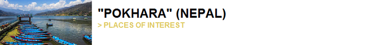
It’s best to find a hostel in Pokhara where you can leave your big bag (with your things you do not want to take with you on the trekking (safe)) and where if you come back you want to stay at least one night. Then it is also important to see if you already have your stuff with you (and try it out) and maybe buy some food or something. Then you will have to go to the "ACAP" office where you get a license and where a fax is sent to your embassy with the period that you walk you’re hike. You can also ask how you get to the starting point of the draw and how to get back.
Take a nice "brinta" porridge in the morning; it is warm, cheap and it fills you up until noon.
What to take into account:
Nepal is a third world country so do not expect a five star hotel with swimming pool, nice restauranst with a big full menu, beautiful rooms with hot water, perfect showers and so on. Electricity failures, things sold out on the menu, showers that do not work (well), clogged (squat) toilets, not all too clean, WIFI what does not work (well) etc.
It is also important that you acclimatise; this is not a walk through the park - you will walk about 6 to 7 hours a day through high (altitude) terrain with wind, rain, sun and rivers, over rocks in unknown terrain and with a decent bag on your back. You can walk in a quick pace at the beginning of the tour and the end, but take it easy on the higher parts. Finally, there is not (yet) a motorway and no public transport. The trekking takes about 10 to 14 days (it depends how fast you walk) so you will have to be in a reasonably good condition, not be sick, flexible and you will have to stay there those days. It will be at least a few days before you are back (or you have to call in a very expensive helicopter).
Options and costs

Of course you can hire a guide, porters and a donkey but it’s not necessary. It’s very hard to get lost - there are plenty of other "Western" tourists on the trail, there are numerous signs and there are countless villages (especially in the lower part) with people who know exactly where you have to go. You get a map from the "ACAP" and with a bit of your own homework (from eg your travel guide) you really get very far. You can often leave your big bag in hostels in "Pokhara" or at least the bulk of your content so that you walk "light". Countless eateries are on the way besides the fact that there are also a large number of hostels and other accommodation options - a sleeping bag, a tent and such things are really unnecessary. Usually there is electricity, WIFI and running water in the hostels. Also, most people (especially people in the hostels) speak English and often also another language. Most people walk counterclockwise because of the steepness of mountains if you do it the other way around.
Buy in Pokhara water purification pills; not only very good for your wallet but also for the environment. You can buy 50 pills for 500 Rs. As mentioned, you can find a place to stay anywhere and there are also many options for eating somewhere. The overnight stays are relatively cheap, but the host owner assumes that you have both dinner and breakfast in his place. That is especially on what he earns his money - eating and drinking. Keep in mind that it will become more expensive as you get "higher" - because food and drinks need to be transported here. Drinking is relatively pricey. Money is sometimes asked for charging you’re mobile or laptop; you also often pay for internet (WIFI). If you do not have a valid license (from "ACAP") and you still want to walk the hike you pay double (4000R).
tips:
-
If you have trained (or are fit at least), you can also walk the route clockwise so that you will encounter far fewer tourists (most of them run counterclockwise);
-
You can also skip the "normal" route (6 to 7 hours a day) and set up your own route so that you sleep in other places where most people sleep;
-
Do not sleep in the first hostel that you encounter in a village; it is usually full, more expensive than the rest and gets (because they have enough patronage) not much more than what is asked of them - walk to a more remote area in town or village and you get a perfect place for good money next to special local hospitality;
-
Do not order "dhal bat" if you do not have to - you will eat this daily if you are "higher" because that is almost the only thing on the menu;
-
Do not take a complete travel guide with you (too heavy) but only a copy of your folder and notes;
-
Stay in Pokhara for a few days, take a few walks through the mountains and acclimatise before leaving to the "real" high mountains;
-
Sometimes host owners allow you to pay a lot for charging electrical things like your cell phone, laptop etc.
-
Make sure you know what to do if you become ill or are sick (altitude sickness);
-
Try to eat yak meat instead of dal bhat - a bit dry but very nutritious;
-
It is of course cozier (and safer) if you walk with several people; make sure you look up people who walk on the same level (the same pace) as you;
-
Buy as many bars (and that kind of dry stuff) in Pokhara (and not on the trail where it is a lot more expensive);
-
Do not try to rush because that would be really a shame - take your time and enjoy (it would also be dangerous for your health);
-
Do some homework before you leave (make the route along the way so that you do not have surprises);
-
Try "at home" all your stuff at least once (it will not be the first time if something works or does not work properly);
-
There are often "electricity failures" so do not count 100% on every day an option to power or charging options;
-
When a group of horses / donkeys or carriers pass by always stay on the "inside" side and not the “outside” – you won’t be the first that falls into a ravine because of it.

the hike (content):
DAY 1: "Besisahar - Bahudanda
-
07:15 bus Pokhara - Besisahar;
- 11:30 arrival in Besisahar; checkpoint
- Besisahar (820 mtr): to Khudi: 7km = 120 minutes
- Khudi (790 mtr): to Bhulbhule: 2 km = 30 minutes
- Bhulbhule (840 mtr): to Ngadi: 4 km = 75 minutes
- Ngadi (890 mtr): to Bahundanda: 4 km = 105 minutes
After the road has gone down slightly, you have to take a slightly sloping path ("Marsyangdi Khola") to "Khudi". This is the first of a number of "Gurung" villages (where many Ghurka soldiers were recruited) that you pass. The view here is fantastic over the surrounding mountains. Now you go up to 840 meters (Bhulbhule) and you have to register at an "ACAP" checkpoint as you now really enter the "national park". You now walk via the village "Lampata" (1135 m) to Bahundanda at 1310 meters altitude. This is a good place to stay for the first night. There are a good number of accommodation options and a number of shops.

DAY 2: "Bahudanda" - "Tal"
- Bahudanda (1310 mtr): to Ghermu: 5 km = 90 minutes
- Ghermu (1130 mtr): to Jagat: 3 km = 90 minutes
- Jagat (1300 m): to Chamce: 4 km = 60 minutes
- Chamce (1385 m): to Tal: 5 km = 150 minutes
At the beginning of day 2 you walk from Bahudanda directly steeply down towards the village "Lili Bhir". Here you walk in open terrain with sometimes a steep part. Ghermu is located in an open valley and has a large waterfall. Syange is your next stop at 1080 meters altitude; here you cross the river "Marsyangdi Khola", over a drawbridge. You continue to follow the river and end up in the village of Jagat. A suitable place for lunch, but it is a filthy village that once made fame as a toll place of the Tibetan salt trade. First you walk a bit down before climbing up again through the forest to Chamce. From there you climb to Tal which is at 1700 meters. Tal is the first village in the "Manang" region. It is a good place to stay, located in an open valley near a natural dammed section of the river.

DAY 3: "Tal" - "Latamarang":
-
Tal (1700 meters): to Karte: 4 km = 90 minutes
-
Karte (1870 mtr): to Dharapani: 2 km = 60 minutes
-
Dharapani (1900 mtr): to Bagarchap: 2 km = 60 minutes
-
Bagarchap (2160 mtr): to Danagyu: 2 km = 45 minutes
-
Danagyu (2200 m): Latamarang: 1.5 km = 60 minutes
After you leave Tal you walk straight through the valley and go up a stone staircase that leads to another bridge that takes you over the "Marsyangdi" river at 1850 meters altitude. This route takes you to "Dharapani" (1920 mtr) which is a great place to stay overnight - it has a beautiful panorama. You enter under a typical Tibetan gate. The next village is "Bagarchap" at 2160 meters altitude; the village consists of stone houses with flat roofs built in typical Tibetan style. In 1995 there was a terrible landslide that destroyed the whole village. You can have lunch here. The route from here is full of rocks and can be described as rough; it climbs via Danagyu where you can take different routes. One of them climbs up to Lattemarang at 2440 meters altitude.
DAY 4: "Lattemarang" - "Pisang"
-
Lattemarang (2440 mtr): to Koto: 5.5 km = 120 minutes
-
Koto (2640 mtr): to Chame: 2 km = 45 minutes
-
Chame (2170 mtr): to Bhratang: 7 km = 120 minutes
-
Bhratang (2850 mtr): to Dhukur P: 6 km = 90 minutes
-
Dhukur Pokhari (3240 mtr): to Pisang: 1.5 km = 90 minutes
From Lattemarang where you are already at an altitude of more than 2400 meters you climb through a conifer forest to Koto which is even more than 200 meters higher. Koto is a quiet, relaxed, small and clean village with, among others, a Tibetan monastery. Here you have a view of the first snowy mountain peaks of Annapurna II. Chaotic "Chame" is your next stop and the main city of the "Manang" district; here you will find a lot of accommodation options, a bank a post office. There are also some hot springs nearby. At the entrance of the city you will find an authentic Tibetan "mani" - a wall with prayer wheels. You now cross the "Marsyangdi Khola" river again to see the mighty rocks of "Paungda Danda" created by a glacier through a forested area in a deep, narrow valley. It is still a short climb via "Dhukur Pokhari" to the high (more than 3000 meters) located city of Pisang which has enough accommodation options. Note: there is a higher and a lower part of Pisang - there is about 100 to 150 meters difference in height between.

DAY 5: "Pisang" - "Manang"
-
Pisang (3240 mtr): to Humde: 7 km = 120 minutes
-
Humde (3450 mtr): to Bhraga: 6 km = 105 minutes
-
Bhraga (3450 mtr): Manang: 2km = 30 minutes
From Pisang there are also two different paths that come together at "Mungji". When you leave Pisang you soon realize that this is the dry "Manang" district where the monsoon rains do not come. Here you can see your first yaks, the mountain cow. It is a decent walk from Pisang via Humde to Bhraga, which is a nice, almost hidden village. From Bhraga it is still a half hour walk to the nice "Manang" where many people stay a day to acclimatize (you crossed the 3500 meters) and hang around. It has some nice hostels, plenty of shops and you can make several day trips here to break up the "trekking". One of them (which you can also enjoy from a distance) is a walk to the beautiful "Gangapurna" glacier.
DAY 6: "Manang" - "Letdar"
- Manang (3540 mtr): to Yak Kharka: 9 km = 180 minutes
- Yak Kharka (4050 mtr): to Letdar: 1 km = 60 minutes
From Manang it goes up steeply; you first enter the hamlet of "Tengi" where you leave the "Marsyangdi" valley and enter the "Jarsang Khola" valley. The vegetation is getting less and less, the number of villages also and eventually you arrive in Yak Kharka. This village has about three hostels and you can have lunch here. From there it is still a short walk (about a hour) to Letdar at more than 4000 meters altitude. Perhaps it is wise to acclimatise here too (over 4000 meters).
DAY 7: "Letdar" - "High Camp"
-
Letdar (4200 mtr): to Thorang Phedi: 5 km = 150 minutes
-
Thorang Phedi (4450 mtr): to "High Camp": 1 km = 60 minutes
Leaving Letdar you will cross the river at over 4300 meters and you will continue to climb to 4420 meters - this is "Thorang Phedi". There are two hotels here. From here it is another hour to what they call "high camp"; the piece to there is pretty steep. "High camp" has various accommodation options and fantastic views. You better stay here than to go over the top because it is still a long stretch to a next stop.

DAY 8: "High Camp" - "Muktinath"
-
"High Camp" (4850 m): to "Thorung Pass": 5 km = 135 minutes
-
"Thorung Pass" (5416 mtr): to Charabu: 6 km = 165 minutes
-
Charabu (4230 mtr): to Muktinath: 4 km = 75 minutes
It is wise to get up at 5 a.m. and leave early. Do not leave at 03:00 because it can be too cold so you cool off too much. Ask locals what the situation is on the pass because there may be snow and ice and it may be that you can not pass the pass or spent hours to cross it. Here no more trees and bushes and a lot of wind; it is pretty steep but you can not get lost and the path is regular. Upstairs you have a breathtaking panorama view over the Annapurna mountains to the vast barren and rugged "Kali Gandaki" valley. It is about 1,500 meters from the top until you reach Muktinath. Halfway there is a very nice (dining) café where you can sit in the sun and enjoy the view. In "Muktinath" you really feel that you are back in the civilized world; you can rent a mountain bike here to finish one of the most adventurous trips on the mountain.

DAY 9: "Muktinath" - "Jomson"
-
Muktinath (3800 m): to Jharkot: 1 km = 60 minutes
-
Jharkot (3550 mtr): to Khinga: 3 km = 45 minutes
-
Khinga (3355 mtr): to Kagbeni: 6 km = 105 minutes
-
Kagbeni (2800 mtr): to Eklebhatti: 2 km = 60 minutes
-
Eklebhatti (2740 mtr): to Jomson: 7 km 120 minutes
Muktinath is a place of pilgrimage for both Buddhists and Hindus and you can visit the Buddhist "gompa" but also the Hindu "Vishnu" temple of "Jiwala Mayi". Hindus come here for the 104 holy water spouts while the Buddhists come for the eternal flame (through the natural gas that comes from the ground). From here you can also take two different paths. The low path takes you in about an hour in Jharkot. Along the way you will probably encounter different types of Tibetan traders and/or "sadhus" (holy men). It continues down through Kingha vend Kagbeni through a beautiful semi-desert landscape. You can already see the nice little town of Kagbeni from afar. The wind can blow horribly here; nevertheless, many people stay at least one day in Kagbeni that is almost an European medieval town. Not far are the plains of the legendary "Mustang" area. The last Tibetan town you visit (before you arrive in Thakali area) is Eklai Bhatti which lies in the middle of the windy valley. Here you can have lunch. From here it is another 2.5 hours to Jomson which is the major important commercial city in the region. It has a hospital, shops, a bank, bus station, an airport and an "ACAP" office. Most hostels are located on the other side of the river (direction airport).

DAY 10: "Jomson" - "Kalopani"
-
Jomson (2720 mtr): to Marpha: 6 km = 90 minutes
-
Marpha (2670 mtr): to Tukuche: 6 km = 90 minutes
-
Tukuche (2590 m): to Kobang: 4 km = 60 minutes
-
Kobang (2640 mtr): to Larjung: 1 km = 60 minutes
-
Larjung (2550 mtr): to Kokhethanti: 3 km = 60 minutes
-
Kokhethanti (2525 mtr): to Kalopani / Lete: 3 km = 60 minutes
Leaving busy Jomson you come across a small hill towards Marpha. This city is known for its orchards with delicious apples and walnuts. You can also buy apple brandy at the brewery, spend the night in luxury and visit a monastery. Still slightly sloping down, the landscape and climate gradually changes from windy and bare to more green and more alive. You end up at Tukuche, once a very important strategic trading center for Tibetan products. It is still the most important "Thakali" village and friendly enough. The Thakali are characterized by a good sense of trade and often own a shop or hostel - not only here but also in Kathmandu and Pokhara.
It is an hour's walk before you reach "Khobang" to recognize the "gompa" above the city. You can have lunch in Larjung and is a nice establishment with small narrow lanes and little tunnels between the houses. If you go to Kokethanti you walk in the "Kali Gandaki" valley with a wide riverbed. This valley lies between the Annapurna I and Dhaulagiri mountain and is one of the deepest gorges in the world. It is only 38 meters wide and the river flows through 2200 meters. You can also find walnut and apple orchards here. Another 3 km (an hour's walk) and you arrive in Kalopani, a good place to stay overnight. You can enjoy the beautiful view here.
DAY 11: "Kalopani" - "Tatopani"
-
Kalopani (2535 mtr): to Ghasa: 7 km = 150 minutes
-
Ghasa (2010 mtr): to Kopochepani: 4 km = 90 minutes
-
Kopochepani (1480 mtr): to Rupsechahara: 2 km = 45 minutes
-
Rupsechahara (1500 m): to Dana: 3 km = 60 minutes
-
Dana (1400 mtr): to Tatopani: 4 km = 90 minutes
Kalopani is about 100 meters higher than Lete but is often regarded as one and the same place. You will first have to return to Lete before you can go to Ghasa which is about 7 km away. It is here steeply down through a forest; Ghasa is the last Thakali town that you come across. You now cross the river a number of times, including a suspension bridge. You now descend hundreds of meters via Kopochepani to Rupsechahara through a narrow steep section of the "Kali Gandaki" valley. The landscape shows wheat fields near Dana for the first time; in Dana you can also have lunch. You have dropped a lot of meters today but you will still go 200 meters down to Tatopani where you can stay overnight. You will walk past parts where landslides have taken place. It is also possible to do shorter treks from Pokhara and stay overnight here. There is a police station and there are hot springs (tato literally means "hot"); Tatopani was an important trading post for the heavy monsoon rains of the late 1980s; the city is slowly recovering from the destruction. It is known for its good food.

DAY 12: "Tatopani" - "Ghorepani"
-
Tatopani (1200 mtrr): to Ghara: 5 km = 135 minutes
- Ghara (1700 mtr): to Sikha: 6 km = 60 minutes
- Sikha (1935 mtr): to Chitre: 1 km = 105 minutes
- Chitre (2350 mtr): to Ghorepani: 2 km = 75 minutes
Remarkably enough you are going to climb again today; first from Tatopani to Ghara no less than 500 meters in 5 km. Eventually you end up in the fairly large city of Sikha at 1935 meters where you can enjoy lunch, shopping and/or an overnight stay. After Sikha you walk along countless terraces farmland with corn until you finally end up in Chitre. You are now far above the 2000 meter limit again. It is now 2 km (including an hour and a quarter) to climb to Ghorepani where you can stay overnight too.
It gives you a good possibility to walk from Ghorepani to "Poon" hill. It is 3 km and takes about one and a half hours - the top of "Poon" is 3210 meters. Keep in mind that especially in the early morning this climb is pretty crowded due to its popularity. The view is unprecedented. You can also walk from the other (like going to the town of Chomrong); the view seems to be better here and with far fewer people.
DAY 13: "Ghorepani" - "Hille"
-
Ghorepani (2870 mtr): to Ulleri: 2 km = 60 minutes
-
Ulleri (2010 mtr): to Tikhedhunga: 2 km = 60 minutes
-
Tikhedhunga (1500 meters): to Hille: 1 km = 30 minutes
From Ghorepani the path quickly goes sloping down; the first two km to Ulleri which is a "Magar" village. Then you have to walk via several stone steps to Tikhedhunga which lies at 1500 meters altitude. You can spend the night in both Tikedhunga and Hille (which is half an hour away).
DAY 14: "Hille" - "Nayapul" ("Pokhara")
-
Hille (1500 mtr): to Birethanti: 4 km = 75 minutes
-
Birethanti (1025 mtr): to Nayapul: 1 km = 30 minutes
From Hille the path will again drop considerably. It is about 4 to 5 km walk until you reach the large village "Birethani. You have to drop another half an hour before you reach Nayapul. Nayapul (1070 mtr) is the terminus of the Annapurna (or partly "Jomson" trekking) and here you can take a bus or taxi back to Pokhara (there is a bus that arrives at 11:00 hrs in Pokhara).

see also:
LANDEN:
EUROPA:
Albanië * België * Bosnië-Herzegovina * Bulgarije * Denemarken * Duitsland * Engeland * Estland * Finland * Frankrijk * Griekenland * Hongarije * (Noord) Ierland * Italië * Kosovo * Kroatië * Letland * Litouwen * Luxemburg * Macedonië * Malta * Montenegro * NEDERLAND * Oekraïne * Oostenrijk * Polen * Portugal * Roemenië * Rusland * Schotland * Servië * Slovenië * Slowakije * Spanje * Tsjechië * Turkije * Zweden
NOORD EN CENTRAAL-AMERIKA:
Chili * Costa Rica * Cuba * Guatemala * Mexico * Nicaragua * Panama * Verenigde Staten
ZUID-AMERIKA:
Argentinië * Bolivia * Brazilië * Colombia * Ecuador * Peru
AFRIKA:
Botswana * Burkina Faso * Egypte * Ethiopië * Ghana * Kenia * Mali * Marokko * Namibië * Oeganda * Senegal * Tanzania * Tunesië * Zuid-Afrika
MIDDEN-OOSTEN:
Iran * Israël * Jordanië * V.A.E.
AZIE:
Armenië * Cambodja * China * Filipijnen * Georgië * India * Indonesië * Japan * Kirgizië * Laos * Maleisië * Mongolië * Myanmar * Nepal * Oezbekistan * Singapore * Sri Lanka * Thailand * Vietnam
OCEANIE:
Voor meer reisfoto's kijk op www.instagram.com/cheapskatetravel.nl:

© Cheapskatetravel.nl; 2018 (all rights reserved)