Travel Stories - France
"somme"

albert
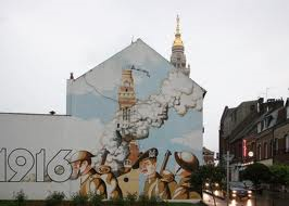
We have to take several busses that go through several small French villages. Finally we end up in the French city of “Albert”, our final destination today. It took about an hour with the bus and we loved it. The first thing that strikes us is the golden "dome" of the city. It is the golden turret of the "Basilique Notre Dame de Brebieres" which would become a French national symbol during WWI and the Battle of the Somme. It was hit by a German grenade but kept standing which was taken as a miracle. "Musée de Somme 1914-1918" is located in an old tunnel which is dug out during the eighty years of war against the Spaniards - for protection. The tunnel is about 2 meters wide, 250 meters long, dark, damped and represents life during the first world war Partly by attributes, situations represented by wax images and partly by information and sound from the trenches. When we walk out of the tunnel we are so disoriented that we search in vain for minutes to find the entrance back where our big bags are placed at the entrance of the museum.
"La Grande Mine"
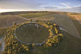
We need to look for a place to stay for tonight (wild-camping) and we assume that we are able to find a suitable place around the "La Grande Mine" just outside the town. Via a large industrial estate we walk towards the village "La Boiselle" where we still see a tip of Albert's golden church tower through the rolling hilly landscape. The word goes that if during the battle of the "Somme" the church tower would remain undamaged the battle would be won - a hope that became true despite the thousands of fallen soldiers. A small road brings us to a, what looks like, a raised sand hill; it is surrounded by trees. When we walk up the hill, you are able to look down into a deep pit. The hole is caused by countless explosives during the war. In this case the explosives werd placed by British miners and were placed under the German trenches, by digging a tunnel underneath. Before the real attack would be deployed, the explosives would go of which would cause a "hole" in the defense as well as great panic by the Germans. On the first day of the first battle for the "Somme" it was detonated. Now it is possible to walk around the crater and I see many "poppies" in the hole, next to other memorial souvenirs.
Since it has already become quite late we really have to start searching for a forest where we can put up our tents. In the distance we see a forest which should be on a walkable distance but we find out, when we come closer, that it’s all fenced off. Next to that it’s not as big as we thought and it’s sloping. Despite this we climb the fence and put up our tent on the side of the forest a bit later. We fry our meat on our heater, eat some bread wit hit and open our cheap wine.

Caribou

Finally a night in which I did not feel cold in the tent; in the morning we immediately pick up our tents and while Pete prepares breakfast I sit against a tree looking over the rolling landscape in front of me. My thoughts go to what it must have looked like here (as a lunar landscape) during WWI and then I return to reality; a yellow field with a hare jumping away when he sees me. After our breakfast we hitchhike back to Albert and when we hear that there is no public transport to "Beaumont-Hamel" we are forced to raise our thumb again. Luckily we have a lift rather fast and our driver takes us all the way (about 10 km) to the "Memorial Park of the Newfoundlanders". At the gate we are greeted by one of the Canadian volunteers.
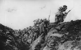
We hear in the information house that a path has been made between two rows of electric fence behind which only sheep can graze because of the still present danger of explosives. Walking along the path with green rolling hills on both sides so that it looks like you are walking in a cave path we see from far away the "Caribou" monument; First we walk to what was once the front line during WW1 before the attack was deployed. Here is the famous "Y-ravine" with many monuments, small cemeteries and the famous zigzag trenches that are still full of mud in winter like those devastating days. Across the road is the village "Beaumount-Hamel" also infamous because of the terrible battle that took placet here. This is one of the places where most victims fell on that particular date of 1 July 1916, the first day of the Battle of the Somme - entire British divisions were swept away, including the volunteers of the Royal Newfoundland regiment. The many craters and parts of trenches in the landscape are the remaining memories of this. We take a look at the dead tree which, like legend, is the only thing that still protrudes 2 meters above the lunar landscape. Also the Scottish monument - the man with the kilt – is standing here.
Arras

Still impressed by the memorial place we sit down on the grass in front of the information house to eat our lunch. Our plan is to hitchhike from here to "Arras" or even "Vimy-ridge". Since that chance is not so big and the weather is fine we decide to walk to what looks like a medium-sized motorway on the map. We hope from there to take a lift. We pass a village where we see a very cozy and nice tea house and some farmers. Then we reach the medium-sized motorway which is indeed larger than the country roads we are crossed but there is almost no traffic. After waiting a while we are picked up by a couple. They first passed us by, turned and picked us up anyway.
They go to Arras and ask if we are interested in walking the city with them when then continuing to “Vimy Ridge”. It sounds to good to be true. A little later we park on a large square "Grand place" surrounded by what looks like Flemish merchant houses from the 17th and 18th century. We walk through "Place de Heros" to the information center. There stand three "Geants", three giants of dolls that mainly serve as carnival decorations. They can be up to 8.5 meters, are mostly based on local heroes, but can also have kids and die. They are called "Colas", "Jacqueline" and the little one is their son "Dede". Time to go to the house of "Robespiere's", the fanatical Jacobin lawyer during the French Revolution. Unfortunately we don’t have a lot of time here so I hope one day I will go back to Arras to check out the city.

Vimy Ridge

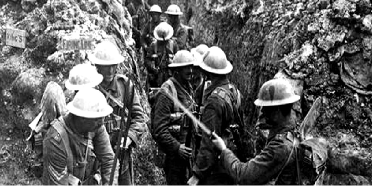
Back in the car we try to figure out if the couple is going to visit “Vimy Ridge” like we want to do or only want to drive there to drop us. Officially, it is called "Canadian Battlefield Memorial Park" and a gigantic white monument makes it clear that we made it. The monument is standing there where the ridge is where the Germans in WWI in 1917 waited for the Canadians and caused a huge amount of casualties. The French thought that it would be a good idea to construct the place like it was before the war. The Canadians, on the contrary, thought differenly and wanted to leave the place like it was on the end of the war. For that reason, the trenches, now some reconstructed, are still in perfect condition and you get a good picture of what it looked like in those days. In 1914 the English had dug 13 tunnels for various reasons; as storage for ammunition and supplies, as protection against mainly artillery bombardments and finally to get under the trenches of the enemy and let bombs explode. We make a free tour through one of the tunnels. The girl takes us back in the time that here was enormous noise because of the constant shelling, there were no toilets and due to that very bad hygiene. It was damped, full of smoke, dirty and very little light due to lack of electricity. Besides the many soldiers and other people who walked around the muddy paths, there were also many rats and vermin that lived here.
The Battle of the Hill of "Vimy":
The ridge of "Vimy" is a slope on the west side of the “Douai” plain, about eight kilometers north of Arras. The ridge has a gentle slope on the west side, but sinks steeper on the east side. The back is about seven kilometers long and goes up to about 145 meters above sea level, about 60 meters above the surrounding plain, offering a clear view in all directions. In October 1914 the ridge had already fallen into German hands at the so called “Race to the Sea”. The 10th French Army tried to expel the Germans from the region during the Second Battle of Artois in May 1915 by attacking their positions on the hills of Vimy and the hill of Notre-Dame-de-Lorette. The French 1st Moroccan Division was able to capture the height, but could not hold on to it due to lack of reinforcements. In September 1915 the French made another attempt at the Third Battle of Artois, but without success. There were about 150,000 deaths and injuries among the French. In February 1916 the British 17th Corps dissolved the French in the sector. On May 21, 1916, the German infantry attacked the British lines about two kilometers in front to push them back from their positions at the foot of the ridge. The Germans took several British tunnels and mine craters before they struck their advance and entered. A British counterattack on 22 May did not change anything. In October 1916 the Canadian Corps dissolved the British 4th Corps.
In April 1917 a large-scale Canadian attack was carried out, which became the “famous” battle of “Vimy”, known as the "Battle of Vimy Ridge". It was the first time that the four Canadian divisions together participated in a battle as a formation. Because of the scale of the planned Canadian attack, they were supported by British divisions. The attack began at 5.30 am on Easter Monday, April 9, 1917. The Germans were pushed back and the first objectives were taken the first day. The attack continued on 10 April and most of the German positions on the ridge were conquered. By the night of 12 April, the Canadians had the hills of Vimy firmly in their hands. On the Canadian side, 10,602 victims had fallen, more than 3,598 dead and 7,004 wounded.

Before we leave we see some German positions and especially the minimum distance (about 25 meters) between the two fighting parties is startling. The German trenches are filled with sandbags with concrete. We also take a quick train-ride through the ultra-modern "Historical interpretive center" to go to the bathroom and then leave. The campsite nearby seems to be closed and I want to go back to Arras as my bus goes back to Amsterdam tomorrow. With an empty stomach we find someone willing to take us to Arras. On a citymap we find a green spot and decide to walk that way. We walk out of the city, towards a small village, called Achicourt. It turns out it’s more a city-forest or a forest-park. It is still quite difficult here to find a suitable tent spot, between all the craters but a little later on a bushy plateau we find two suitable spots for our tents.
tips & advice (2010)

-
Name: wild camping spot "La Boiselle"
Content:
Not far from the big crater ("le Gran Mine") we found a spot near the hamlet "La Boiselle" where we could camp wild. Not exactly know where it was along a narrow asphalted winding road that zigzagged past farms and fields. Near a large villa (it looked like a small castle) was a fence and behind that what looked like a large forest - this turned out to be a strip of forest with some trails - not really suitable for camping but we had little choice. This terrain is rolling and there is little forest.
-
Name: wild camping spot "Achicourt"
Content:
Near the bus station in Arras you can walk towards the hamlet "Achicourt" - at one point (it is still quite a walk) you come across a forest city park where you can find a place to camp. Far from ideal I have to say - there are craters, something similar to trenches and small hills with bushes where you can not put your tent on. In addition, it can be pretty swampy. At the edge of the park there is a kind of plateau with low bushes - here you can find a flat spot.

see also:


LANDEN:
EUROPA:
Albanië * België * Bosnië-Herzegovina * Bulgarije * Denemarken * Duitsland * Engeland * Estland * Finland * Frankrijk * Griekenland * Hongarije * (Noord) Ierland * Italië * Kosovo * Kroatië * Letland * Litouwen * Luxemburg * Macedonië * Malta * Montenegro * NEDERLAND * Oekraïne * Oostenrijk * Polen * Portugal * Roemenië * Rusland * Schotland * Servië * Slovenië * Slowakije * Spanje * Tsjechië * Turkije * Zweden
NOORD EN CENTRAAL-AMERIKA:
Chili * Costa Rica * Cuba * Guatemala * Mexico * Nicaragua * Panama * Verenigde Staten
ZUID-AMERIKA:
Argentinië * Bolivia * Brazilië * Colombia * Ecuador * Peru
AFRIKA:
Botswana * Burkina Faso * Egypte * Ethiopië * Ghana * Kenia * Mali * Marokko * Namibië * Oeganda * Senegal * Tanzania * Tunesië * Zuid-Afrika
MIDDEN-OOSTEN:
Iran * Israël * Jordanië * V.A.E.
AZIE:
Armenië * Cambodja * China * Filipijnen * Georgië * India * Indonesië * Japan * Kirgizië * Laos * Maleisië * Mongolië * Myanmar * Nepal * Oezbekistan * Singapore * Sri Lanka * Thailand * Vietnam
OCEANIE:
Voor meer reisfoto's kijk op www.instagram.com/cheapskatetravel.nl:

© Cheapskatetravel.nl; 2018 (all rights reserved)